Disaster Management

Adroit sources best in breed sensors to provide accurate, reliable environmental monitoring solutions to meet common disaster management requirements such precipitation, flood detection and water levels, tilt and groundwater levels to improve public safety and protect infrastructure. Iridium satellite connectivity ensures continuous data in remote areas even during serious weather events.

Fixed Site Installation

A variety of fixed mounting options for disaster management sensors are available including deployment to existing structures such as bridges (flood detection) and waterbores (groundwater levels). The Adroit groundscrew provides a relocatable option and is perfectly suited for tiltmeters and rain buckets.
PMK Noise

Disaster Management Flood Detection and Water Level Monitoring

Monitoring
Key Benefits
Analytics

Disaster Management Flood Detection and Water Level Monitoring

Adroit flood detection and water level monitoring for disaster management utilises a contactless radar sensor to accurately measure water levels in real-time. The sensor is solar powered for remote locations. Iridium satellite connectivity ensures continuous data in remote areas even during serious weather events.

Key benefits

Feature rich platform and app

Customisable thresholds and alerts, downloadable data and APIs for integration

}Real-time monitoring

Get a clear view of water levels from a range of water environments

Data driven decisions

Real-time data and alerts aids critical decision making in response to environmental events

Not used on desktop

Not used on desktop

Not used on desktop

Parameter

Water level height (m).

Standards

Common environmental monitoring standards for flood detection and disaster management.

Deployment

Fixed mounting onto existing structures such as bridges, dams and water tanks, between 0 and 15 meters from the water body surface.

not used on desktop

fAccurate and reliable measurements

Highly accurate, cost-effective, reliable, field proven and calibrated radar sensor measures water levels

Health and safety

Ensure a compliant, healthy and safe environment for employees, surrounding communities and infrastructure

Rich data sets

Visualise real-time and historic data to aid in environmental management and planning

Fixed

Visualisation and Analytics

Use the Adroit platform to visualise your flood detection and water level limits and receive threshold alerts on any connected device including mobile to aid in compliance, health & safety and complaint mitigation.

The addition of Adroit Analytics enables: automated reporting, AI for identification of trends and insights, tracking of site performance to aid in compliance and overall geotechnical site management.

Water Levels

Disaster Management Tilt Monitoring

Monitoring
Key Benefits
Analytics

Disaster Management Tilt Monitoring

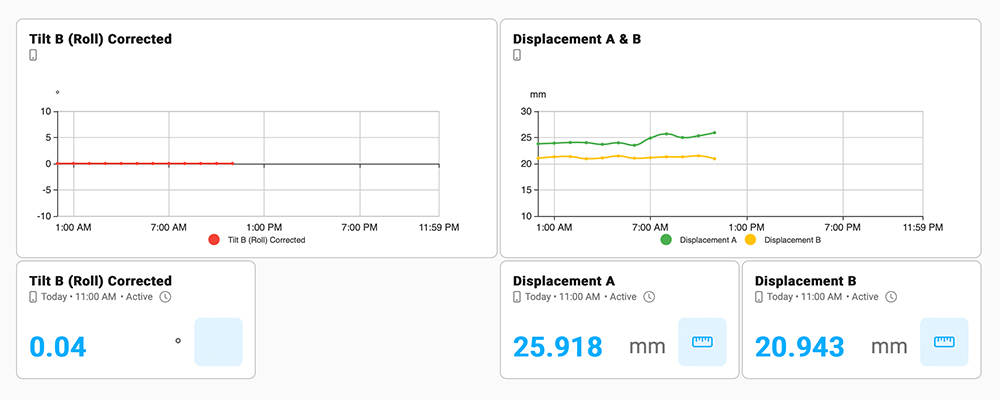
Adroit tilt monitoring for disaster management utilises a highly accurate tri–axial tiltmeter sensor, with sensitivity of 0.001 degrees, that can detect even the smallest changes in slope or tilt, providing early warning of potential hazards such as landslides, sinkholes, or structural instability. Common disaster management applications include worksites, slope stability, dam safety monitoring and structural monitoring. Iridium satellite connectivity ensures continuous data in remote areas even during serious weather events.

Key benefits

Feature rich platform and app

Customisable thresholds and alerts, downloadable data and APIs for integration

}Real-time monitoring

Get a clear picture of ground movement or tilt on your site at any point in time

Adaptive installation

Tiltmeter monitoring can be a fixed mount or pole mounted including groundscrew

Not used on desktop

Not used on desktop

Not used on desktop

Parameter

Angle of tilt in degrees in XY axis and calculated displacement in (mm).

Standards

Common environmental monitoring standards for tilt monitoring and disaster management applications.

Deployment

Tiltmeters can be deployed using a groundscrew method, wall mounted brackets are available for buildings and structures.

not used on desktop

fAccurate and reliable measurements

Highly accurate, cost-effective, field-proven and factory-calibrated tri-axial sensor measures tilt to 0.001 degrees

Health and safety

Ensure a compliant, healthy and safe environment for employees, surrounding communities and infrastructure

ZImproved disaster management

Historic and real-time data to aid disaster management, public safety and protection of infrastructure

Fixed

Visualisation and Analytics

Use the Adroit platform to visualise your tilt level limits and receive threshold alerts on any connected device including mobile to aid in disaster management, health & public safety and protection of infrastructure.

The addition of Adroit Analytics enables: automated reporting, AI for identification of trends and insights, tracking of site performance, increases in efficiency and improvement of overall environmental and disaster management.

Tilt Levels

Disaster Management Groundwater Level Monitoring

Monitoring
Key Benefits
Analytics

Disaster Management Groundwater Level Monitoring

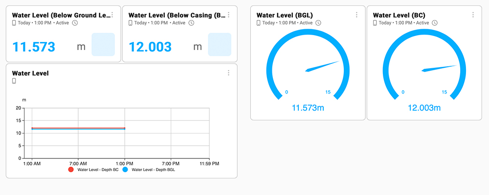
Adroit groundwater level monitoring for disaster management monitoring utilises a water pressure sensor to calculate below ground water levels. There are 3 deployment options available: Toby caps, ground well caps and upstands. Having accurate real-time data of changes to groundwater levels can provide early warnings and valuable data for flood prediction and landslide prevention. Automation in data collection to reduce operational costs, improve health & safety and aid in compliance. Iridium satellite connectivity ensures continuous data in remote areas even during serious weather events.

Key benefits

Feature rich platform and app

Customisable thresholds and alerts, downloadable data and APIs for integration

}Real-time monitoring

Get a clear picture of groundwater levels, conductivity and temperature

Adaptable installation

Installation to any existing water bore or manhole cover

Not used on desktop

Not used on desktop

Not used on desktop

Parameter

Sensor monitors groundwater level in (meters), other units can be applied upon request.

Standards

Common environmental monitoring standards for groundwater levels and disaster management.

Deployment

Groundwater level sensors can be deployed using existing water bores of any diameter, typical install methods include, well caps, toby caps, and upstands.

not used on desktop

fAccurate and reliable measurements

Highly accurate, cost-effective, field proven and factory calibrated sensors measure various groundwater parameters

Health and safety

Ensure a compliant, healthy and safe environment for employees, surrounding communities and infrastructure

tDisaster management and decision making

Historic and real-time data to aid disaster management, public safety and protection of infrastructure

Fixed

Visualisation and Analytics

Use the Adroit platform to visualise your groundwater level limits and receive threshold alerts on any connected device including mobile. Use of automation improves health & safety for employees and surrounding communities.

The addition of Adroit Analytics enables: automated reporting, AI for identification of trends and insights, tracking of site performance to aid in compliance and overall geotechnical site management.

Groundwater Levels